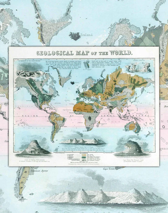


Geological Map of the World 1852 - Print

Envío inmediato
Fabricamos con cariño; pide este producto hoy para tenerlo entre el Martes 21 de Julio y Viernes 24 de Julio.

Fabricamos con cariño
Pide este producto hoy para tenerlo entre el Miércoles 22 de Julio y Martes 28 de Julio.
- Size: 80x63cm
- Printing: Canson PhotoMatt 180gr paper. specialized for art reproduction and long duration.
- Scale : 1 : 2,160,000
- Shipping: Within Santiago, other shipments choose Lamina format.
This 1852 Map, was engraved by John Emslie by hand in colour, shows the worldwide distribution of various types of rocks. It includes references that it identifies: alluvium (sedimentary), igneous (primary, secondary and tertiary), metamorphic (changed) and volcanic.
Geology studies have their roots in ancient times, when humans began to observe the rocks, minerals, and geological formations that surrounded them. However, Geology as a modern science began to develop in the 18th century , with the work of geologists such as James Hutton in Scotland and Charles Lyell in England. These scientists made systematic observations and studies of rocks and geological strata, which allowed them to establish the fundamental laws and principles of geology.
In the 19th century, geology became a very important discipline due to the increased exploitation of mineral resources, especially in Europe and North America. In this context, geological maps became a crucial tool to explore and exploit the riches of the subsoil. The first modern geological map was created by William Smith in England in 1815, and since then, geological maps have become an essential tool for the exploration and development of mineral resources throughout the world.