


Maule, Biobío and Araucanía - Chiletur Tourist Map

Envío inmediato
Fabricamos con cariño; pide este producto hoy para tenerlo entre el Miércoles 01 de Julio y Lunes 06 de Julio.

Fabricamos con cariño
Pide este producto hoy para tenerlo entre el Jueves 02 de Julio y Miércoles 08 de Julio.
To travel has been said!
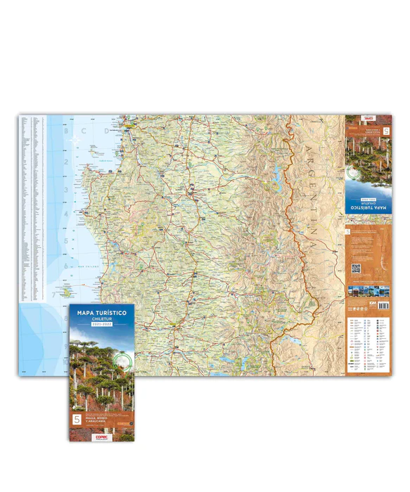
2 maps printed on both sides covering 530 kilometers from north to south, from Rengo/Pichilemu to Lake Caburgua. Highlights: Río Cipreses Reserve, Siete Tazas National Park, Altos de Lircay National Reserve, Ñuble, Ralco and Malleco National Reserve, Conguillío and Huerquehue National Park and the entire coastal road from Pichilemu to Tirúa.
- Extended size : 100 x 70 cm.
- Paper : Stonepaper 140 microns
More about these maps:
The Chiletur Copec tourist maps designed by Compass are 18 Tourist and Route maps, divided into 9 products printed on both sides. These include all of Chile from Visviri to the entire Antarctic.
Printed on Stone Paper, this is an ecological mineral paper that does not use trees, water or chemicals for its preparation, very resistant, waterproof, anti-reflective and recyclable; which makes them very durable, unlike those made of paper.
Its scale is 1:400,000, which means that 1 cm. equals 4 km. This allows a detailed understanding of the representation of the terrain covered and allows a better visualization of distances, route variations, slopes, paths and tourist attractions.
For its preparation, the cartographic database of the Military Geographic Institute (IGM) was used. In it, all the georeferenced routes of the Ministry of Public Works were downloaded, complemented by a permanent investigation on the ground by the publisher.